AI-Driven Deforestation Analysis & Land Use Intelligence
Satellite-based land use change detection to verify deforestation-free status for regulatory compliance and carbon market eligibility.
Run time-series analysis, validate cut-off dates, and generate audit-ready land intelligence for EUDR, sustainable sourcing, and carbon project registration.
DART: Deforestation and Risk Assessment Toolkit
Fast, accurate, and accessible deforestation analysis through advanced satellite-based technology.
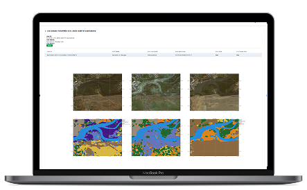
Rapid Deforestation Insights
Analyze land plots in minutes with our satellite-based time series tool. Get precise deforestation insights and generate comprehensive reports, complete with visual evidence.
Global Coverage, Zero Complexity
No need to define an area of interest. Access analysis for any location worldwide with Sentinel-2 satellite data, delivering unmatched accuracy and convenience.
Visual and Actionable Reports
Receive detailed reports with high-quality imagery that highlight historical land changes. Make informed decisions backed by clear, visual evidence.
Seamless Integration
DART comes with API access, enabling integration with your existing software systems for a streamlined and automated workflow.
Comprehensive Land Intelligence Infrastructure
Plot-Level Boundary Mapping
Upload KML files or digitally map polygons to define exact sourcing or project boundaries.
Historical Time-Series Analysis
Assess land cover change across multiple years to identify deforestation events or degradation trends.
Cut-Off Date Validation
Verify land status against regulatory cut-off requirements such as EUDR or corporate sourcing policies.
Forest Classification & Risk Scoring
AI-based classification of forest types, canopy density, and deforestation exposure risk.
Satellite Evidence Reports
Generate visual and data-backed reports suitable for auditors, buyers, and compliance teams.
API & System Integration
Integrate land intelligence outputs into dMRV systems, compliance dashboards, and supply chain traceability platforms.
Where DART Is Applied
EUDR Compliance
Validate deforestation-free sourcing for coffee, cocoa, palm oil, soy, rubber, timber, and cattle-linked supply chains.
Carbon Project Baseline Validation
Confirm historical land eligibility before ARR, agroforestry, or nature-based project registration.
Sustainable Procurement Programs
Screen suppliers for forest-risk exposure and ongoing deforestation monitoring.
Climate Finance & Investment Due Diligence
Assess land-related environmental risk before capital allocation.
Built For
Commodity Exporters & Traders
Ensure shipments comply with deforestation regulations.
Carbon Project Developers
Validate land eligibility and avoid registration rejection.
Agribusiness & Global Brands
Strengthen deforestation-free sourcing claims with satellite evidence.
Climate Funds & Financial Institutions
Integrate land-risk intelligence into ESG and climate investment decisions.
Prove Land Integrity Before You Claim Sustainability
Generate satellite-backed deforestation analysis reports aligned with regulation and carbon methodology requirements.